Curriculum
Earth Observation expert with 20+ years of experience spanning academic research, international programme management, and open-source development. Known for bridging scientific depth with real-world application — from forest monitoring, disaster detection, to European space policy.
Education
| Year | Degree | Institution |
|---|---|---|
| 2015 | University Teaching Qualification (BKO/UTQ) | Wageningen University, Netherlands |
| 2006 | PhD Bioscience Engineering & Geomatics | KU Leuven, Belgium |
| 2002 | MSc Earth Observation (Magna Cum Laude) | Purdue University (US) & KU Leuven (BE) |
| 2000 | MSc Bioscience Engineering (Cum Laude) | KU Leuven, Belgium |
| 1997 | BSc Biological Engineering (Cum Fructu) | KU Leuven, Belgium |
PhD title: Monitoring Vegetation Dynamics with Hyper-temporal Satellite Data to Improve Fire Risk Assessment in Savanna and Forest Ecosystems. Field campaigns in South Africa (Kruger National Park), in collaboration with Stellenbosch University and CSIR South Africa.
Career
Earth Observation Programme Manager — BELSPO, Belgium (2022–present) Belgian Delegate at ESA and EU Copernicus programme boards. Focus on EO data applications, science innovation, and operational service uptake across industry and academia. Key activities include engagement with the Copernicus Emergency Management Service, Destination Earth, and national stakeholders on urban heat, climate risk, and near-real-time monitoring.
Associate Professor — Wageningen University, Netherlands (2015–2022) Led a research group on change detection and ecosystem monitoring. Supervised 2 postdocs and up to 6 PhD students. Secured major grants from ESA, EU Horizon 2020, Google, and national funders (NWO, NWO-NL, BELSPO).
Assistant Professor (Tenure Track) — Wageningen University (2012–2015)
EU Marie Curie Postdoctoral Fellow — Wageningen University (2010–2012) Integrating terrestrial LiDAR and satellite time series via radiative transfer models.
Postdoctoral Research Fellow — CSIRO, Australia (2007–2010) Operational forest monitoring for Victoria (Australian Government). Collaborated with Prof. Rob Hyndman (Monash University) to develop the BFAST software package.
Technical Skills
- Programming: R (fluent), Bash, Linux HPC environments, GitHub, Python
- Earth Observation: Sentinel-1/2, MODIS, Landsat; time series analysis, change detection, land cover mapping
- Big data & platforms: openEO, FAO SEPAL, Destination Earth (DestinE), Copernicus Data Space Ecosystem
- Languages: Dutch, English, French
Selected Awards & Recognition
- Excellent Teaching Award, Wageningen University — 2017 & 2018 (Geo-Scripting course)
- Google Research Award — 2013 (USD 130k) & 2015 (USD 80k) (near-real-time deforestation monitoring, Google Earth Engine)
- CSIRO Performance Award — 2008 (excellence in satellite forest monitoring research)
- EU Marie Curie Fellowship — 2010–2012
Selected Invited Talks & Keynotes
- Presentation, BeGEO 2026, Brussels — Operational Flood and Emergency Mapping from Space: How Belgium, ESA and EU Copernicus Turn Data into Decisions
- Keynote, IIASA Geo-Open-Hack, Austria (June 2024)
- Panel discussion, AI4Copernicus (May 2024)
- Keynote, ESA Living Planet Symposium (2022) — EO for ecosystem resilience monitoring
- Invited talk, Tipping Points Workshop, Bern (2022) — towards IPCC special report
- Tutorial, IGARSS, Athens (July 2024)
- Keynote, Geo-Info Brazil (2015); Multi-temp conference, Belgium (2017)
PhD Students Supervised
Kim Calders · Johannes Reiche · Michael Schultz · Ben Brede · Ben DeVries · Eliakim Hamunyela · Patrick Brandt · Paulo Bernardino · Dainius Masiliūnas (defended May 2024)
Science Communication
- MetOp-SG A1 weersatelliet — VRT NWS (August 2025) — quoted on the Sentinel-5 instrument and daily atmospheric monitoring
- ESA Biomass satelliet lancering — VRT NWS (April 2025) — quoted on radar-based forest monitoring through clouds and canopy
- ESERO Belgium National Partners Day (August 2025) — presentation on Copernicus Earth Observation and open satellite data
- IIASA Geo-Open-Hack 2024 keynote
- AI4Copernicus panel discussion (2024)
- Nature Today: ecosystem monitoring
Fun find
A newspaper clipping (~2006–2007) covering my doctoral research on satellite-based fire risk prediction, kindly dug up by my mother-in-law decades later.
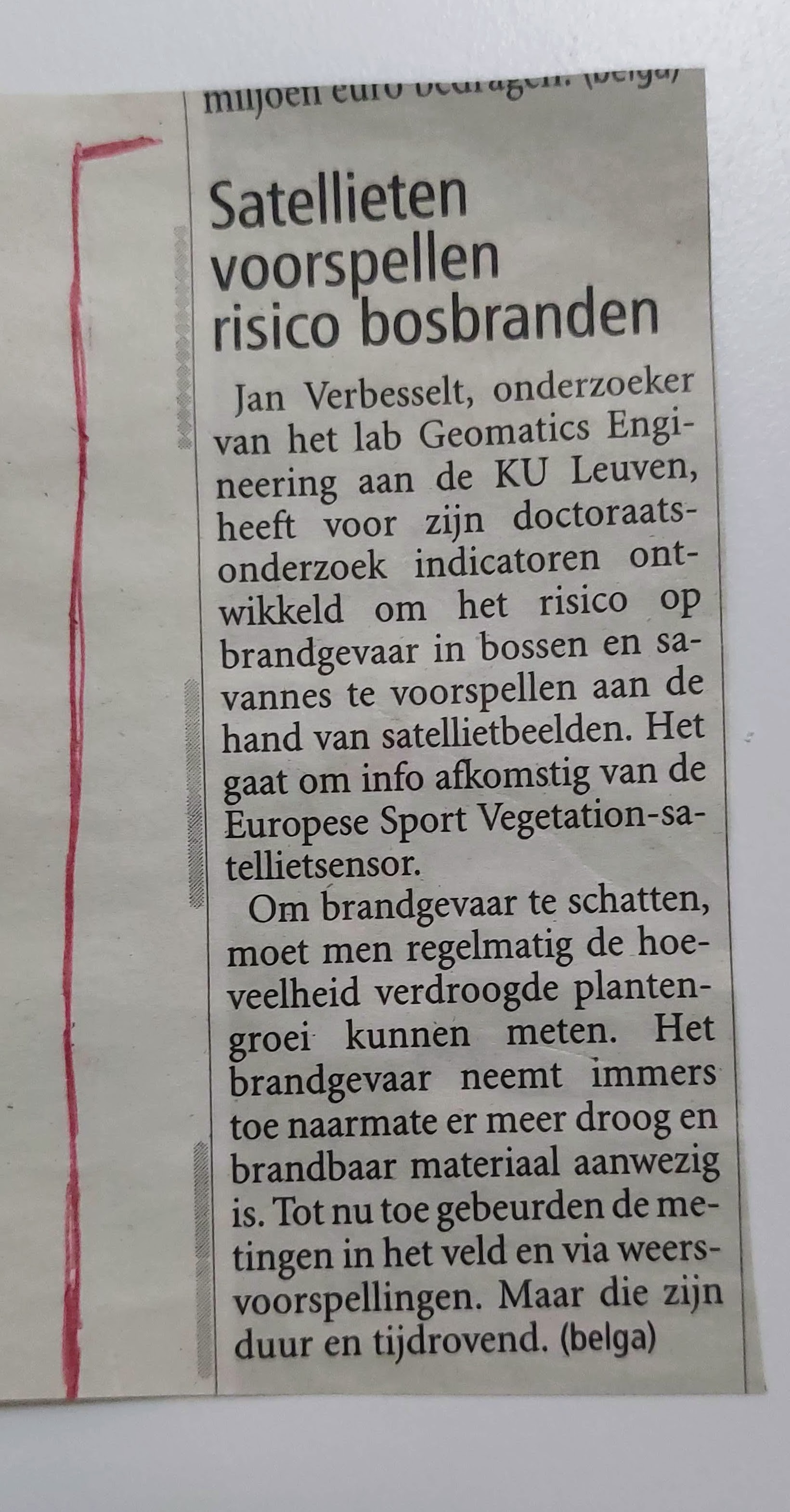
English summary: The article reports on doctoral research at KU Leuven’s Geomatics Engineering lab developing indicators to predict fire risk in forests and savannas using satellite imagery, drawing on data from the SPOT Vegetation satellite sensor. Estimating fire risk requires regularly measuring the amount of dried-out vegetation, since risk increases with more dry, flammable material present. At the time, such measurements relied on costly and time-consuming field surveys and weather forecasts.